Geodesy & Geoinformation
In principle, geodesy (greek: to divide the earth) deals with surveying and mapping of the earth's surface. Due to the fact that many generations of surveyors spent their time on this task, one of the most frequently asked questions are:
"When will you finish surveying?"
In fact, it is not that difficult to give an answer to this question: never! On the one hand, our environment changes continuously and on the other hand higher and higher accuracies are demanded for the results of geodetic surveys. In this context the application of the latest technologies and the modelling of more and more complex systems has to be mentioned. In many cases the accuracy demanded nowadays for modeling certain effects would not have been obtainable with the equipment used several years ago.
Besides that, the field of activity for surveyors extends continuously: whereas surveyors formerly confined themselves to gathering and editing of data, they are often involved in the process of planning and in other use (e.g. analysis and interpretation) of the gathered data today.

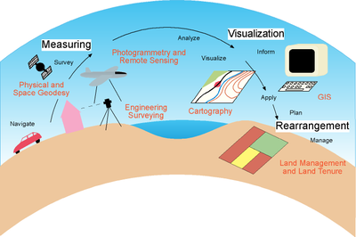
Measuring
The first step is the acquisition of raw data, i.e. measurements are carried out (e.g. measuring the geometry and position of objects like houses or roads). Depending on the dimensions and the accessibility of the specific object, different techniques are used. One possible way is the determination of distances, angles or height differences between well-defined points on the earth's surface. For this purpose various instruments are available. For other applications air- or space-born techniques are appropriate. A camera on-board a plane or a satellite takes pictures of the earth and geodetic informations are derived from these pictures afterwards.
Visualization
For human beings it's hard to deal with the results of a measurement by just looking at a huge amount of numbers. Therefore these numbers have to be 'translated' into something more illustrative. Well-known to everybody, it is common use since hundreds of years to represent the results of geodetic surveys in cartographic maps. Apart from that, so-called geoinformation systems (GIS) were established during the last years. These are not only used for representation purposes, but also for the maintenance and analysis of the data.
Rearrangement/Application
Finally one would like to benefit from the new information. Hereunto a few examples from different fields of interest:
- Reorganization of land tenure
- Delimitation and monitoring of big developments (tunnels, bridges,...)
- Improved prediction of satellite orbits based on better gravity field data
- Navigation of vehicles with the help of satellite-based positioning and digital road networks
- Orientation with the help of maps
For more details please see our homepage.
